· 3D Hardware
· 3D Software
· 3D Video
· 3D TV and Movies
· 3D Art
· 3D Picture of the Day
· 3D Modeling
· 3D Printing
· Reviews
· Gaming
· How To
· News
· Everything Else
· Off Topic
· Around the Web
· Virtual Reality
Posted by: Jim on: 10/30/2012 02:30 PM
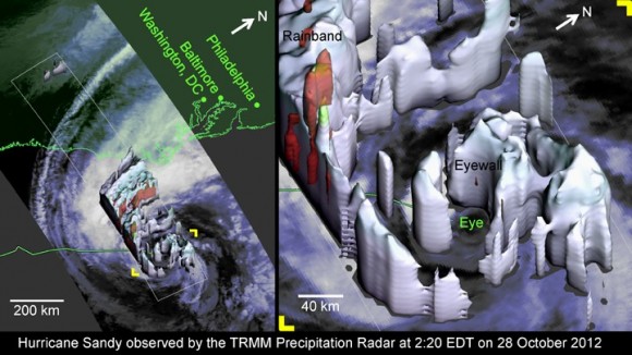
NASA has been hard at work with Hurricane Sandy on the approach. The space geeks have temporarily repurposed their tropical rainfall monitoring satellite to grab a 3D view of the eye at the center of the most powerful hurricane since 1821, all while the International Space Station has recorded its progression along the East Coast of the US. The 3D graphics from the Tropical Rainfall Measuring Mission show that Sandy has a relatively small eye, yet is carrying a whole lot of power.

“TRMM-observed properties of Hurricane Sandy’s eyewall are evidence of remarkable vigor. Most hurricanes only have well-formed and compact eyewalls at category 3 strength or higher. Sandy was not only barely a category 1 hurricane, but Sandy was also experiencing strong wind shear, Sandy was going over ocean typically too cold to form hurricanes, and Sandy had been limping along as a marginal hurricane for several days” NASA
“TRMM-observed properties of Hurricane Sandy’s eyewall are evidence of remarkable vigor. Most hurricanes only have well-formed and compact eyewalls at category 3 strength or higher. Sandy was not only barely a category 1 hurricane, but Sandy was also experiencing strong wind shear, Sandy was going over ocean typically too cold to form hurricanes, and Sandy had been limping along as a marginal hurricane for several days” NASA

